
AntiquitiesThe Islamic centuries

The forts of Abu Qir

The forts of the Abu Qir headland that guarded Alexandria’s eastern approach: the castle (El Borg), probably of the late Mamluk period, which saw the battles of 1799 and 1801; Kousa Pasha’s fort of 1807, a registered monument; and the Tawfikiya and Raml forts.

The story

What sets it apart

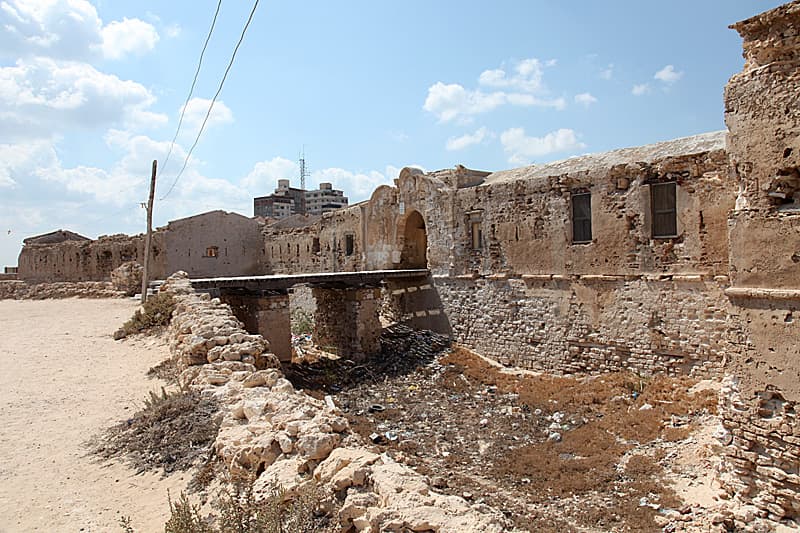
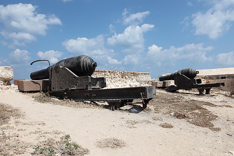
Limestone walls, moats, wooden bridges and Armstrong guns on the Abu Qir headland

  • 1El Borg castle at the tip of the peninsula, listed since 1964
  • 2Kousa Pasha’s fort and its moat (1807)
  • 3Armstrong guns dated 1870
  • 4The ground of the battles of 1799 and 1801

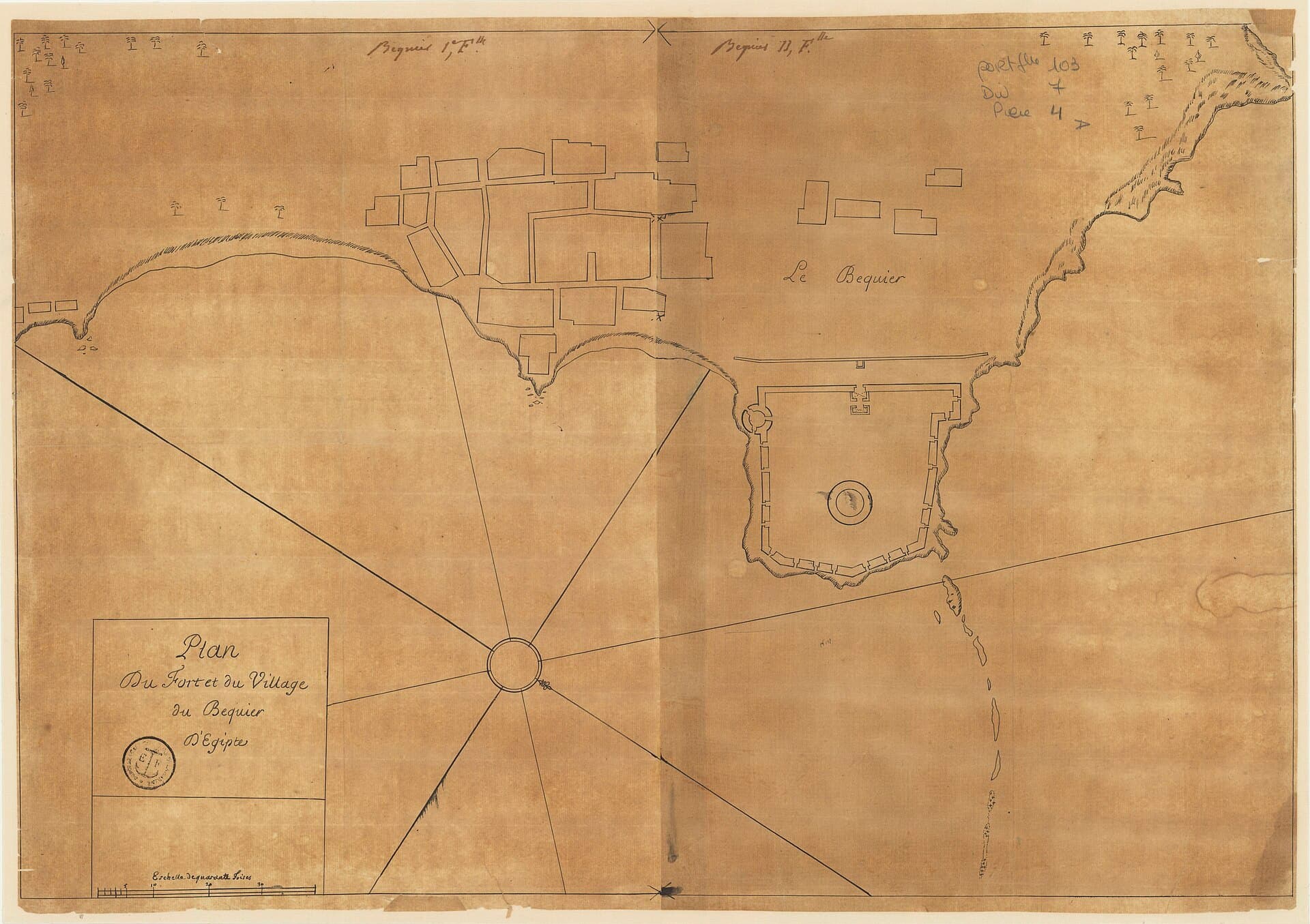
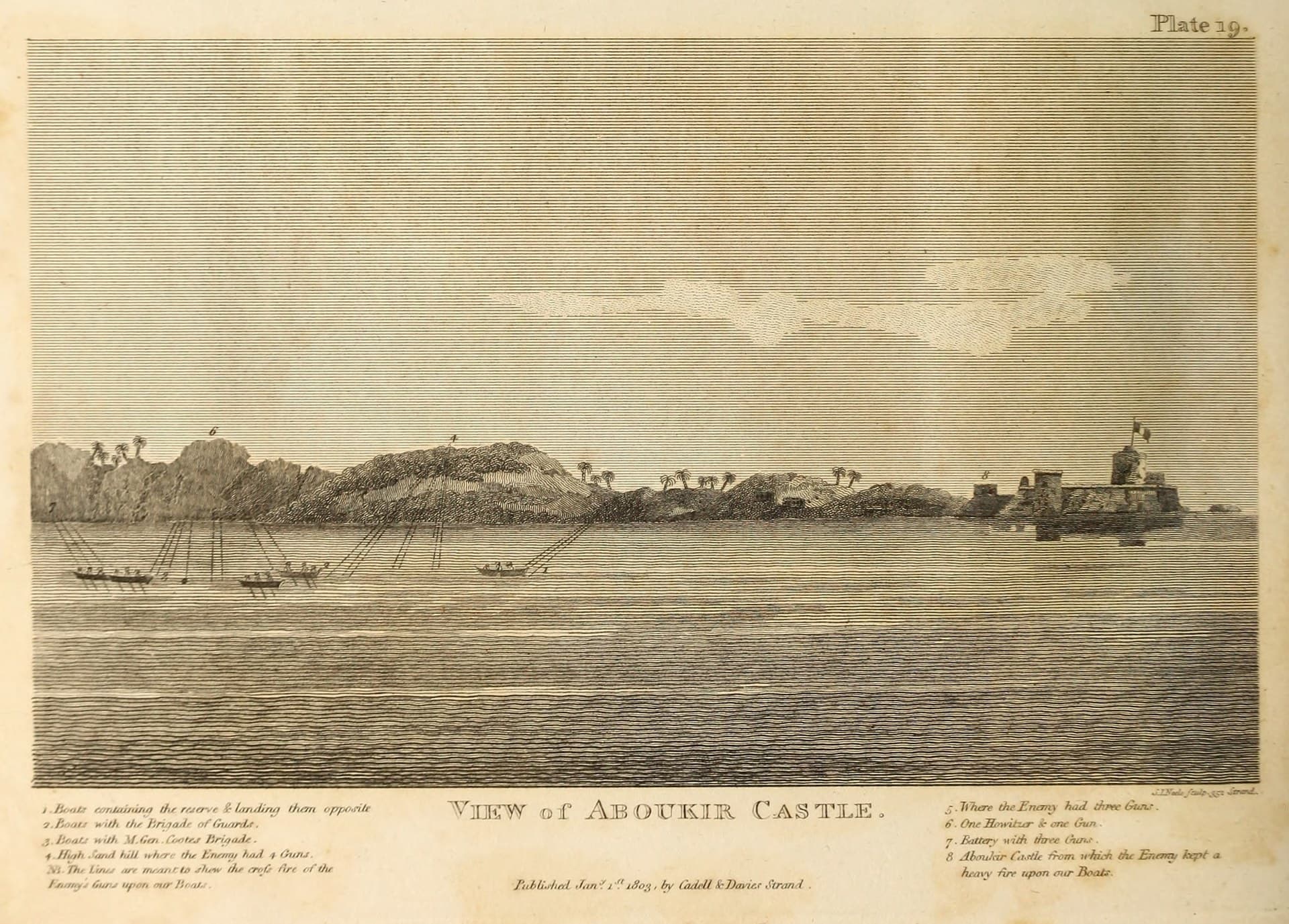
A study published in 2013 counts four forts at Abu Qir: El Tawfikiya, Kousa Pasha, El Borg and El Raml. The most important is Abu Qir castle, or El Borg, at the tip of the peninsula inside the naval harbour; the researchers date it to the end of the Mamluk period. Mohamed Ali and later Abbas Helmi renewed it, and it has been a listed monument since 1964. The castle already appears on a French plan of 1687, “Plan of the fort and village of Bequier”.

On 14 July 1799 an Ottoman army landed in Abu Qir Bay and quickly overwhelmed the French garrison of 300 in the castle; Bonaparte defeated it on 25 July, when Murat’s cavalry charged both its flanks. On 1 March 1801 a British army under Sir Ralph Abercromby reached the bay; it landed on 8 March and forced the French off the beach, and Alexandria fell after a siege on 2 September 1801.

In 1807, after the British Fraser expedition withdrew, Mohamed Ali ordered Kousa Pasha’s fort, also known as El-Sabaa, built on a sandy hill above the sea, with a high outer wall and a moat about 20 metres wide and 8 metres deep. Under Khedive Ismail it was given Armstrong guns, and in 1992 it was registered as an Islamic and Coptic monument. In 2013 the forts stood inside military zones; in September 2026 a proposal to restore Kousa Pasha’s fort for visitors was being studied.
The Islamic centuries7th century – 1805

Its place in time

  1. Before itAbu Qir BayFrom about the 8th century BC: Thonis-Heracleion
  2. This landmarkThe forts of Abu QirThe castle, on a French plan of 1687
  3. After itThe Mandara Windmill1807

On the timeline of all the landmarks

Memories of the place

Every memory is taken from a published, documented source, named under it.

  1. Late Mamluk periodSources differ on this date

    Researchers date Abu Qir castle (El Borg) to the end of the Mamluk period, though some think it Ayyubid because its walls and tower resemble Saladin’s citadel in Cairo. It is the most important fort at Abu Qir because it saw the fighting of the French campaign; Mohamed Ali renewed it, and later Abbas Helmi added a hospital.

    Source: Shahira Sharaf Eldin, Fatima Fekry and Adel El Menchawy, “Abu Qir fortresses as vital assets for tourism motivation and community development”, Wiadomości Konserwatorskie / Journal of Heritage Conservation 34 (2013), pp. 48–53

  2. 1687

    The castle was drawn on a French plan titled “Plan of the fort and village of Bequier”, kept by the Bibliothèque nationale de France.

    Source: “Plan du fort et du village du Bequier d’Egipte” (1687), Bibliothèque nationale de France, record copied on Wikimedia Commons

  3. 14–25 July 1799

    An Ottoman army landed in Abu Qir Bay on 14 July and quickly overwhelmed the French garrison of 300 in the castle; Bonaparte defeated it on 25 July, sending Murat’s cavalry against both its flanks.

    Source: J. Rickard, “First Battle of Aboukir, 25 July 1799”, History of War (26 Jan 2006)

The other memories7
  1. 1–8 March 1801

    A British army under Sir Ralph Abercromby reached Abu Qir Bay on 1 March; delayed by bad weather, it could not land until 8 March, when it met fierce resistance but forced the French off the beach. Alexandria fell after a siege on 2 September 1801.

    Source: The Essex Regiment Museum: the Battle for Aboukir Bay in 1801

  2. 1807

    Mohamed Ali ordered Kousa Pasha’s fort built at Abu Qir after the failure of the British Fraser expedition; it is named after one of his senior commanders, who later became Abu Qir’s administrative governor. A high wall and a moat about 20 metres wide and 8 metres deep surround it, crossed by a wooden bridge whose remains still stand.

    Source: Mohamed Abdel Ghani, «طابية كوسا باشا بالإسكندرية.. من حصن منيع لصد هجمات الغزاة عن المدينة إلى وكر للبلطجية», Al-Ahram Gate (16 May 2016)

  3. The 1870s and 1882

    Under Khedive Ismail the fort was given Armstrong guns, and its guns and garrison played a prominent part in the events of the Urabi revolution in 1882.

    Source: Mohamed El-Badry and Mohamed Amer, «خندق بعمق 8 أمتار ومدافع تحت الأرض.. أسرار طابية كوسا باشا في الإسكندرية», Masrawy (1 Sep 2026)

  4. 1992Sources differ on this date

    Kousa Pasha’s fort was registered as an Islamic and Coptic monument by Ministerial Decision 232 of 1992 according to Masrawy, or 231 of 1992 according to the 2013 study.

    Source: Mohamed El-Badry and Mohamed Amer, «خندق بعمق 8 أمتار ومدافع تحت الأرض.. أسرار طابية كوسا باشا في الإسكندرية», Masrawy (1 Sep 2026)

  5. 2013

    All four forts stood in military zones closed to the public; Kousa Pasha’s fort was occupied by families of former coastguard workers, and four Armstrong guns dated 1870 remained in it.

    Source: Shahira Sharaf Eldin, Fatima Fekry and Adel El Menchawy, “Abu Qir fortresses as vital assets for tourism motivation and community development”, Wiadomości Konserwatorskie / Journal of Heritage Conservation 34 (2013), pp. 48–53

  6. 16 May 2016

    Al-Ahram found large parts of Kousa Pasha’s fort collapsed, and Alexandria’s antiquities director said it urgently needed restoration.

    Source: Mohamed Abdel Ghani, «طابية كوسا باشا بالإسكندرية.. من حصن منيع لصد هجمات الغزاة عن المدينة إلى وكر للبلطجية», Al-Ahram Gate (16 May 2016)

  7. September 2026

Around it

  • This landmark
  • A landmark nearby: open it

Map: © OpenStreetMap contributors